What El Niño means for your next trip, and how to check your own risk
NOAA and the WMO have confirmed El Niño conditions are active in the Pacific and strengthening heading into the Northern Hemisphere fall and winter. That matters for travelers because El Niño reliably shifts where storms, rainfall, drought and heat show up around the world — it just doesn’t shift them the same way every time.
This hub exists to separate what is actually happening right now from what forecasters expect could happen, and from what has happened in past El Niño cycles — three different things that are easy to blur together in headlines. Below, you’ll find direct answers to the questions travelers ask most, a snapshot of the disruption types El Niño can cause, and a set of tools built to check your own destination, dates, and departure checklist rather than rely on generic advice.
El Niño Quick Answers
The essentials on the El Niño 2026–2027 travel advisory, answered directly.
What is happening with El Niño right now?
NOAA’s Climate Prediction Center placed the Pacific under an El Niño Advisory on August 13, 2026, with sea surface temperatures continuing to warm above average in the equatorial Pacific. The WMO has likewise confirmed El Niño conditions are underway. This is the current, observed state — not a forecast.
When could travelers begin seeing impacts?
NOAA’s outlook gives a greater than 90% chance the event stays very strong through Northern Hemisphere fall and winter 2026–27, with further strengthening projected into October–December. This is a forecast, not a certainty, and travel-relevant effects vary by region and typically build gradually rather than arriving on a fixed date.
Which regions should travelers watch?
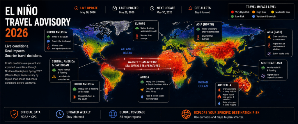
El Niño historically affects different regions in different ways — some see increased rainfall and flooding risk, others see drought. Check the Destination Risk Map for historical patterns by country rather than relying on general assumptions.
→ See cities most affected in past El Niño eventsHow can El Niño disrupt a trip?
Common disruption categories include heavy rain and flooding, drought and water shortages, extreme heat, wildfires and smoke, storms, and flight delays or rerouting. See the Travel Impact Snapshot below for how each of these can affect an itinerary.
Should travelers change or cancel their plans?
Not necessarily — most travelers do not need to cancel plans based on El Niño alone. The right move is to check destination-specific risk, review your airline’s and accommodation’s change policies, and confirm conditions again closer to departure.
→ Get the full pre-departure checklistTravel Impact Snapshot
How El Niño patterns can translate into on-the-ground travel disruption.
Heavy Rain & Flooding
Road closures, landslides and airport-access problems can disrupt itineraries in affected regions.
Drought & Water Shortages
Reduced water supply can affect hotels, tour operators, and local infrastructure in dry-pattern regions.
Extreme Heat
Elevated temperatures can affect outdoor activities, health risk, and comfort for travelers.
Wildfires & Smoke
Fire risk and smoke haze can lead to air quality issues, evacuations, and closures near affected areas.
Storms
Storm intensity and tracks can shift, raising the chance of disruption in coastal and tropical regions.
Flight Disruptions
Weather-driven delays, cancellations and rerouting become more likely in affected flight corridors.
Plan Your Trip
Choose what you need to check before you travel.
El Niño Trip Risk Calculator
Determine potential El Niño-related risks for your destination and travel dates.
Check My TripDestination Risk Map
Explore historical El Niño impacts and potential travel concerns by destination.
Explore the MapCities to Watch
See destinations that have experienced significant impacts during previous El Niño events.
View CitiesEl Niño Preparedness Checklist
Plan ahead before booking and during the weeks leading up to departure.
Get the ChecklistTraveling Somewhere Specific?
Continue into EpicLayover’s destination-level guides for city conditions, airport operations, and layover planning relevant to your route.
Once a storm gets a name, it’s too late to insure against it.
Most travel insurers stop covering a specific storm the moment it’s named or officially forecast. During an El Niño year, that window closes faster than usual. Get a plan in place while it’s still just a forecast, not a headline.
Run one search and get real quotes from dozens of providers ranked side by side, filtered for coverage that actually includes weather-related cancellation, not buried in fine print you’d have to hunt for yourself.
Compare Quotes FreeBuilt specifically for travelers crossing borders, with emergency medical and trip interruption limits sized for a real evacuation or hospital stay abroad, not the token amount some legacy plans quietly cap you at.
View EKTA PlansIf flooding, extreme heat, or a storm turns into a hospital visit instead of a delayed flight, this is the plan built around that exact scenario. Get a quote online in minutes, no agent call required.
Get My QuoteThe earlier you buy, the more protection you lock in. Wait until a storm is already forecast for your dates, and the exact coverage you need may no longer be for sale.
EpicLayover may earn a commission if you purchase through these links, at no extra cost to you.
Where El Niño Actually Changes Travel Conditions
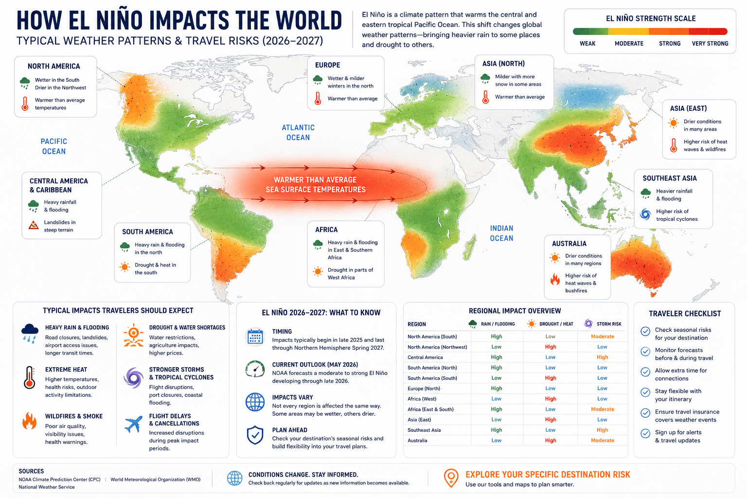
El Niño does not affect the whole planet the same way. The same warming event can flood one coastline while drying out another on the same continent. Here is where the pattern historically shows up, why, and what it means for trip planning.
Why one event produces opposite effects
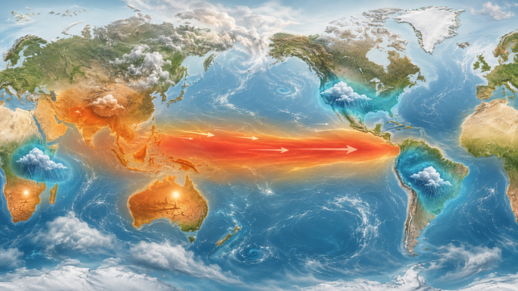
El Niño begins with warmer-than-average water building up in the central and eastern tropical Pacific and the trade winds that normally push that warm water west weakening or reversing. That single shift moves the Pacific’s rain-producing thunderstorm clusters and pulls the jet streams that steer weather systems into new positions.
How that reaches your destination
Regions that normally rely on the trade winds for rain, such as Indonesia and northern Australia, tend to dry out. Regions downstream of the relocated storm track, such as coastal Peru and the southern United States, tend to get wetter. The same reshuffled jet stream also changes storm formation in the Atlantic and Pacific hurricane basins.
Pacific South America
Wetter / flood riskCountries to watch: Peru, Ecuador, northern Chile
Warm coastal Pacific water fuels heavy convective rainfall along a coastline that is normally arid, overwhelming rivers and roads not built for sustained rain.
The 1982–83 El Niño caused 596 deaths and roughly $2.4 billion in damage in Peru; the 1997–98 event killed over 200 and displaced hundreds of thousands in flooding and mudslides.
Watch coastal flood and landslide advisories between roughly November and April, and build extra time into itineraries that cross rivers or coastal highways.
Southern Africa
Drier / drought riskCountries to watch: South Africa, Zimbabwe, Zambia, Mozambique, Botswana
El Niño weakens the moisture flow that normally feeds the subcontinent’s rainy season, reducing rainfall over a wide area during the growing and travel seasons alike.
The 1991–92 drought affected an estimated 86 million people, about 72% of the region’s population at the time; during the 2015–16 event, roughly 2.4 million people in Zimbabwe (about 26% of its population) faced food insecurity.
For safari and overland travel, confirm water availability with lodges and parks in advance, and ask operators whether wildlife-viewing patterns have shifted with the drought.
East Africa
Wetter / flood riskCountries to watch: Kenya, Somalia, Ethiopia, Tanzania
The same Pacific warming shifts patterns in the western Indian Ocean, which tends to push East Africa’s short rains well above average rather than drying the region out.
Past strong El Niño events have driven flooding that displaced more than 200,000 people across East Africa and triggered waterborne disease outbreaks in affected areas.
Check road and bridge conditions before overland travel between regions, and confirm flood advisories for coastal and river-adjacent accommodation.
Southeast Asia & Australia
Drier / drought & fire riskCountries to watch: Indonesia, Philippines, Papua New Guinea, Australia
Warm water in the central Pacific suppresses the rain-producing convection that normally sits over the Maritime Continent and northern Australia, extending the dry season and raising fire risk.
Nine of the ten driest winter-spring periods in southeast Australia have occurred during El Niño events, and the 2015–16 event coincided with the worst Great Barrier Reef bleaching on record. Indonesia’s dry-season fires have repeatedly closed national parks and triggered regional smoke haze.
Check air quality indexes and national park closures before visiting Indonesian nature sites, and monitor bushfire and reef-condition advisories for Australian travel during dry-season months.
South Asia
Mixed, leaning drierCountries to watch: India and monsoon-dependent neighboring countries
El Niño tends to pull moisture-laden winds toward the Pacific instead of across the subcontinent, weakening the Indian monsoon unless offset by other ocean patterns in a given year.
Of 16 El Niño events since 1950, roughly 7 significantly disrupted the Indian monsoon, with notably severe drought years including 1918, 1965, 1972, 2002 and 2009. Effects vary considerably by year.
Monsoon-season travel (roughly June–September) may run drier and hotter than average; confirm water availability for rural and trekking destinations before departure.
North America & the Caribbean
Mixed, location-dependentCountries/areas to watch: Southern & southwestern United States, Caribbean, Pacific coast of Mexico and Central America
El Niño pushes the Pacific jet stream further south, steering more storms across the southern US, while increased Atlantic wind shear makes it harder for hurricanes to organize there. The eastern and central Pacific basin, by contrast, becomes more favorable for storm formation.
Strong El Niño winters have historically brought wetter conditions to the Southwest and Gulf Coast; Atlantic hurricane seasons during El Niño years tend to run quieter, while eastern Pacific hurricane activity affecting Mexico’s Pacific coast tends to run more active.
Atlantic/Caribbean storm risk is typically lower but not zero; Pacific Mexico and Central America coastal areas can see elevated storm activity. Winter travel in the Southwest US may involve wetter roads and trail conditions than usual.
- NOAA / Water Resources Research Center, University of Arizona — global ENSO impact summary
- Weather Underground (Category 6) — historical Peru El Niño flood damage and fatality data
- SBS News — 2026 Indonesia dry-season fire and haze reporting
- The Print — study of Indian monsoon droughts linked to El Niño since 1950
- NOAA / AOML — Atlantic and Pacific hurricane season ENSO relationship
- Climate Extremes Australia — Australian drought, bushfire and Great Barrier Reef bleaching history